Three different reaches of the Little Bear River were studied in this project. All three reaches were situated in entirely different locations from each other. Reach 1 lies in a confined valley setting with very steep slope of the bed. This imparts a high stream power which in turn governs the sediment transport and reworking process. Bed rock exposed, narrow valley bottom dictates the planform of reach 1. So, the river reach is almost straight and would remain like that for a very long time. This reach is a smooth transporter of sediments that it gets from the upstream hills and steep valley slopes on the sides.
Similarly, reach two is located in a partially confined valley setting. It is planform controlled and has the ability to adjust laterally. However, the reach seems to be in stable equilibrium for a long time and doesn't experience considerable variation in discharge and sediment fluxes because of the Porcupine reservoir which a huge sink for sedmients as well as discharge.
Reach 3 is the most downstream part and is classified as a laterally unconfined reach. It will keep on changing its path laterally unless it is restrained from doing so by human beings.
Figure below shows the longitudinal profile of the mainstem river along with the locations of the study reaches. The profile follows the typical convex profile with higher slope at the upstream and mild at the downstream. The slope is very steep at reach 1 and becomes milder at reach 2. Reach 3 lies at the most downstream part and the river is almost flat there. A lot can be inferred about the stream power if reliable discharge data is available for each of the reaches.
The drainage area increased as we moved down the reach. With increasing drainage area we expect a proportionate increase in discharge. However, its not the case here due to the presence of reservoirs and their regulated flow. This is the reason that we have less discharge in Reach 2. So, the reworking of geomorphic units is highly restricted for this reach. Reach three is located at considerable distance downstream from the reservoirs. Other small creeks drain to the river at various places adding to the river discharge even if the hyrum dam restricts the natural continuity of flow. It can be asserted that the river at reach 3 has enough ingredients to exhibit change in the future.
The drainage area increased as we moved down the reach. With increasing drainage area we expect a proportionate increase in discharge. However, its not the case here due to the presence of reservoirs and their regulated flow. This is the reason that we have less discharge in Reach 2. So, the reworking of geomorphic units is highly restricted for this reach. Reach three is located at considerable distance downstream from the reservoirs. Other small creeks drain to the river at various places adding to the river discharge even if the hyrum dam restricts the natural continuity of flow. It can be asserted that the river at reach 3 has enough ingredients to exhibit change in the future.
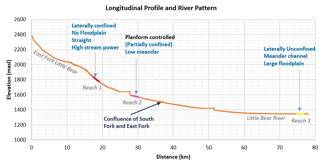
Figure 18: Reach 1,2 and 3 in the longitudinal river profile
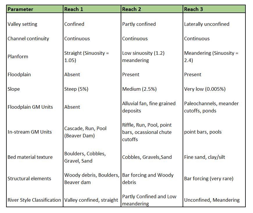
Table below condenses the overall findings from studying the river reaches and presents a concise overview of the river styles.