1. LOCATION
The river system under consideration is the Little Bear River system. Current study encompasses almost all length of the Little Bear River. The most downstream reach for this study is located a few kilometers upstream from the confluence with the Logan River.
All of the Little Bear River and its watershed lie entirely in Cache County, Northern Utah, United States as shown in figure 1. The Little Bear River has two major perennial headwater drainage system which are South Fork and North Fork. These two headwaters meet near a place called Avon. Downstream the confluence of South Fork and North Fork, the river system is known as the Little Bear River. The river system has two major manmade reservoirs, Hyrum reservoir and Porcupine reservoir which are located respectively in Little Bear and East Fork Little Bear river. The river system eventually drains into the Cutler reservoir but before that it joins with the Logan River.
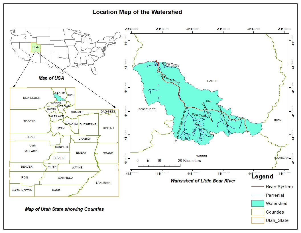
Figure 1: Location map of the Little Bear River watershed and its river system
|
2. CLIMATE, VEGETATION AND FLOW REGIMES
The watershed has mostly a humid climate with dry hot summers and cold winters. Precipitation occurs mostly in the form of snow during the spring periods. The precipitation in the watershed ranges from around 1214 mm/year to 446 mm/year. The precipitation is maximum at higher elevations and minimum at the lower elevations. The upper reaches of the Little Bear watershed receives comparatively greater precipitation than the lower reaches as shown in figure 2 . A typical flow hydrograph for the river is shown in figure 3 (Station at Paradise, Utah). The discharges in the river are highly variable. Usually the flows in the unregulated parts of the catchment are high during the late springs due to the melting of the snow from the upper catchments with lower base flows during the summer. However, the reservoir regulation would significantly govern the flow in the downstream reaches. Summer flows can be higher as irrigation water from the dam returns back to the river. The vegetation cover in the catchment is shown in figure 2. The watershed is mostly dominated by herbaceous grassland which lies towards the downstream part of the catchment. It also has a significant amount of irrigated cropland in the alluvium deposits in the valley. The upper catchment comprises of tree canopy and dwarf shrublands. |
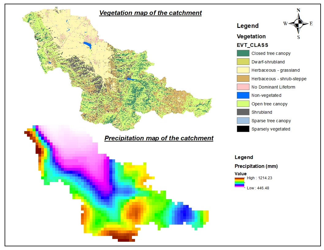
Figure 2: Vegetation cover and precipitation amount over the Little Bear River watershed
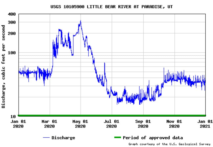
Figure 3: Discharge hydrograph of the Little Bear River (Station:Paradise,UT)
|
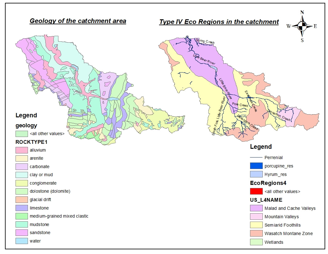
Figure 4: Lithological (left) and Ecological (right) features of the Little Bear River watershed
|
3. TOPOGRAPHIC AND GEOLOGIC SETTING
The watershed comprise of high mountains and low valleys with elevation ranging approximately from 2872 masl to 1343 masl as shown in figure 6 (below). The formation of the landforms in terms of rocktype is shown in figure 4 on the left. The upstream reach where the East Fork originates comprise of conglomerates. The middle part of the catchment is dominated by mudstones and limestones which are relatively weak and erodible. The lowermost reach lies within the remenants of the ancient Bonneville Lake. Soil is comprised mostly of finer materials such as silt, clay/mud. Alluvium deposits are present along the river starting from Porcupine Reservoir to the very end. |
As shown in figure 4, the South Fork and East Fork Little Bear runs mostly through semiarid foothills and the Little Bear River runs entirely through the Cache valley.
|
4. CATCHMENT MORPHOMETRICS
The watershed has an elongated shape with an area of approximately 774.16 Km2 at the lowermost reach (Reach 3 in this study). The morphometric parameters for the Little Bear watershed is shown in Table 1. The longitudinal profile of the river along the mainstem length (74.49 km) is shown in figure 5. Three distinct knickpoints are present. The first knickpoint is natural whereas the other knickpoints are due to the manmade reservoirs. |
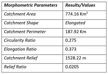
Table 1: Morphometrics of the watershed
|
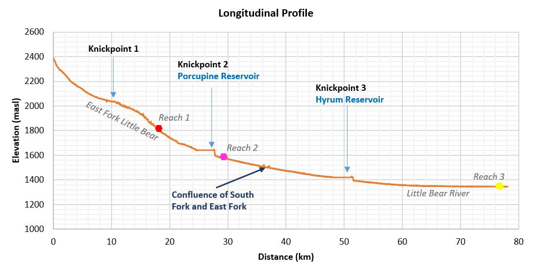
Figure 5: Longitudinal profile of the Little Bear River
5. OVERVIEW OF STUDY REACHES
Four different reaches have been considered for studying and contrasting the riverstyle as shown in Figure 6(a) and Figure 6(b). Reach 1 and Reach 2 are located in the East Fork Little Bear River. Similarly Reach 3 is located in the Little Bear River. Reach 1 is the most upstream reach whereas Reach 3 is the most downstream reach.
Four different reaches have been considered for studying and contrasting the riverstyle as shown in Figure 6(a) and Figure 6(b). Reach 1 and Reach 2 are located in the East Fork Little Bear River. Similarly Reach 3 is located in the Little Bear River. Reach 1 is the most upstream reach whereas Reach 3 is the most downstream reach.
|
Different features of the study reaches are shown in Table 2. Three reaches were studied and all of them are different in terms of confinement.
|
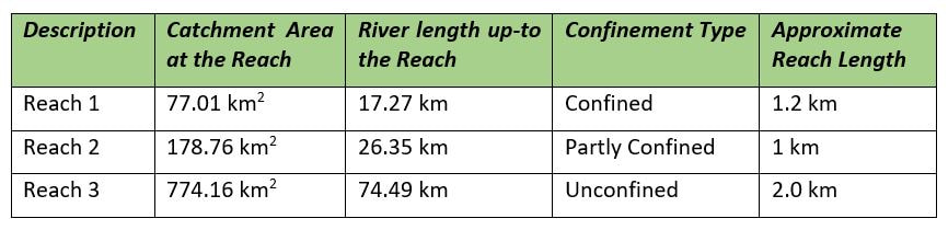
Table 2: Typical features of the study reaches
|
