1. Catchment Length
The catchment length of the watershed is 92.241 Km (92241 m). It has been calculated by taking the distance of the farthest point in the catchment from the mouth of the Logan River along the stream channel as shown in Figure 1 (end of the page).
2. Catchment area of Logan watershed
The catchment area of the Logan watershed is 646.56 square kilometers (646560000 square meters). The area has been calculated from the shape file of the watershed using Arc GIS.
3. Catchment perimeter length
The catchment perimeter length of the Logan watershed is 172341.6 m (172.3416 km). The perimeter has been calculated directly from the shape file of the watershed using Arc GIS. A new field for perimeter can be added in the attributes table and perimeter length can be calculated by performing calculate geometry.
4. Circularity Ratio
Circularity ratio (Rc) = Au/Ac
Where,
Au = Area of the catchment
Ac = Area of the circle having the same perimeter as that of the catchment
Radius of equivalent circle (r) = Catchment perimeter/2π = 172341.6/2π = 27429 m = 27.429 km
Therefore,
Area of circle = πr^2 = π x (27.429) x (27.429) = 2363.577 km^2
So,
Rc = Au/Ac = 646.56 / 2363.57 = 0.274
5. Elongation ratio
Elongation ratio (Er) = A^0.5/L
Where,
A = Catchment area = 646.56 km^2
L = Catchment length = 92.241 km
Hence,
Elongation ratio (Er) = (646.56)^0.5/92.241 = 0.276
6. Form factor
Form factor (Rf) = A/L ^2
Where,
A = Catchment area = 646.56 km^2
L = Catchment length = 92.241 km
Hence,
Form factor (Rf) = (646.56)/92.241^2 = 67.32 = 0.076
7. Catchment relief
Catchment relief is the difference between the elevation at the mouth of the catchment (ELmin) and the highest elevation in the catchment (ELmax).
Catchment relief (H) = ELmax - ELmin = 2890 - 1344.247 = 1545.753 m
8.Relief ratio
Relief ratio (Rh) = H/L
Where,
H = Catchment relief = 1545.753 m
L = Catchment length = 92241 m
Hence,
Relief ratio (Rh) = 1545.753/92241 = 0.0168
9. Drainage density (Logan River perennial network)
Drainage density (Dd) is the ratio of the total length of stream channels to the area of the catchment (A). The total drainage length is obtained by adding the length of all the drainage networks. For the purpose of this assignment the total length of drainage network (Logan River perennial network) has been obtained by using the GIS tool and is equal to 216.678 km.
Drainage denssity (Dd) = 216.678/646.56 = 0.33512 km/km^2
Hence, drainage density of Logan River perennial drainage network = 0.33512 km/km^2
10. Drainage pattern
The Logan River watershed has a dendritic type of drainage pattern. If we look at the drainage network they look similar to the veins in a leaf. Similarly, the smaller tributaries join their major stream mostly at an acute angle. There are not any distinct structural components controlling the drainage pattern.
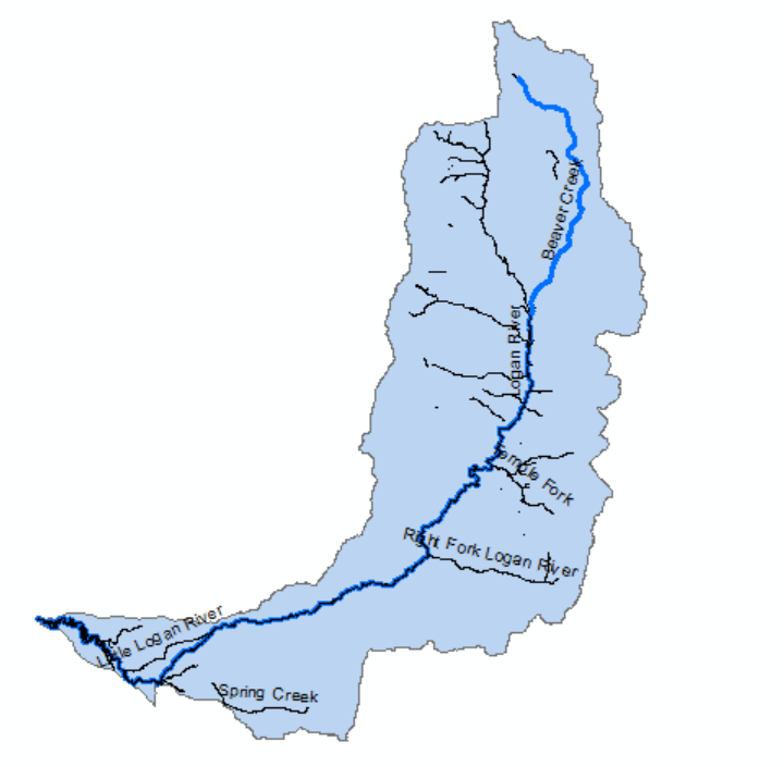
Figure 1: Catchment Length of the Logan River (shown by blue line)
