Reach 1 is the most upstream reach of the East Fork Little Bear River in this study. It has predominantly steep terrain and fast moving water. The reach has an approximate study length of 1.2 km. It lies a few 100 meters from the confluence of East Fork Little Bear and the Cinammon Creek. As, it was not possible to assess the site in person, secondary data have been used to analyse the river style for this reach. Location of the reach 1 in the catchment context is shown in Figure 7 ( Also refer Figure 6 in Introduction ).
A series of google earth imagery (Figure 8) along with other available secondary datasets have been analysed to study this reach. Please click this link to view the study reach in google earth web.
A series of google earth imagery (Figure 8) along with other available secondary datasets have been analysed to study this reach. Please click this link to view the study reach in google earth web.
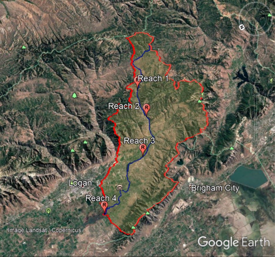
Figure 7: Location of the reaches in catchment context
|
|
The catchment area upstream of the Reach 1 is approximately 77.01 square kilometers which significantly governs the discharge in the river at that reach. The elevation at the upstream and downstream point of reach 1 are 1800 masl and 1740 masl respectively. This means in a short span of 1.2 km the elevation of the river drops by 60 meters (5% slope) making it a very steep reach.
|
The river reach is geologically controlled and the planform follows the shape of the valley itself. Flow occurs in the form of a single threaded channel. The sinuosity of the reach is 1.08, which means its almost a straight reach. Confinement is provided directly by the valley margins on both the sides. Steep hill slopes are present on either sides of the reach. It is almost 100% laterally confined which can be clearly seen in Figure 9 on the left and Figure 10 (below).
There are no distinct floodplains apart from occassional flood pockets that might be present at different locations (Not distinctly seen in imagary here. However, on zooming they can be seen). The planform and typical cross section of the reach is shown in Figure 10. The reach is very steep which means the river flows mainly in the form of cascades and runs. Lack of floodplain means there are no floodplain units in the reach. Although there is no visible anthropoginic footprints in the reach, beaver activity is very common creating an ocassional pool called beaver dam in the river. Such activity leads to the formation of bars just downstream of the beaver dam. |
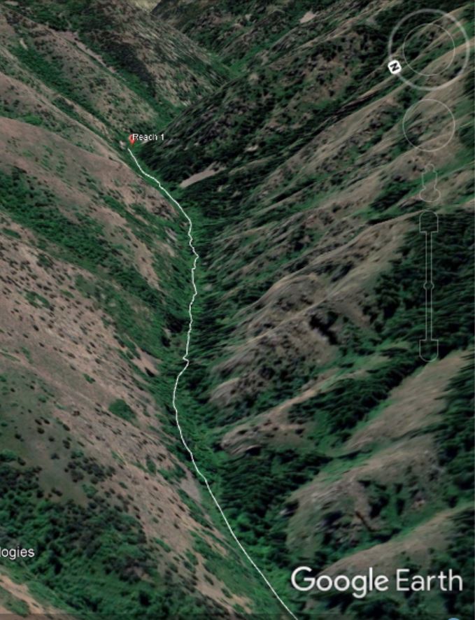
Figure 9: Reach 1 and its confining valley
|
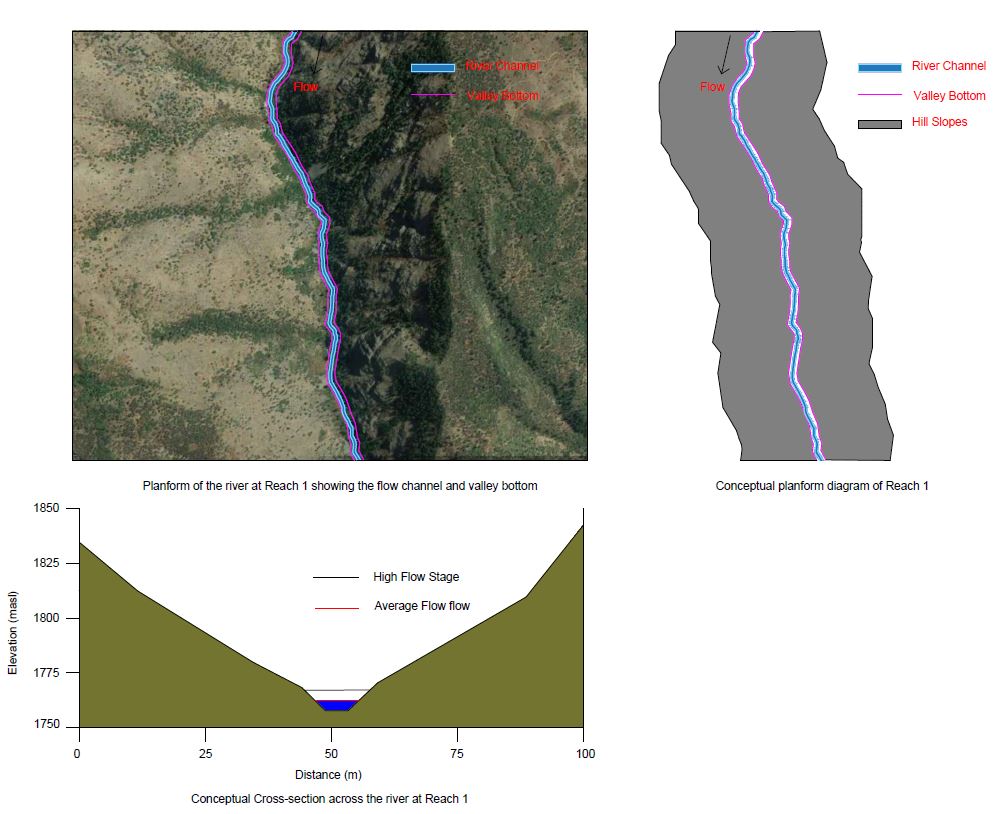
Figure 10: Planform diagrams and typical conceptual cross-section at Reach 1
The size of the river sediment can be expected to be bigger in this reach and comprised mostly of large boulders, gravel and exposed bedrock in many places. The river power is high in this reach due to very steep slopes that would wash away all the fines.
Historic images of the reach indicate a very static channel (having same planform due to lateral confinement) and this can be expected for the future too unless the valley bottom expands by the erosion of the hill slopes and river gets more space to wander. But, it would take possibly thousands of years for that.
Historic images of the reach indicate a very static channel (having same planform due to lateral confinement) and this can be expected for the future too unless the valley bottom expands by the erosion of the hill slopes and river gets more space to wander. But, it would take possibly thousands of years for that.
A concise summary table for this reach is given in the synthesis.
