Reach 2 lies just downstream of the Porcupine reservoir and has a reach length of around 1 km. A desk study was followed by a field visit to study this site. Please click this link to view the study reach in google earth web.
Location of Reach 2 is also shown in Figure 11. A series of google earth imagery (Figure 12) along with other available secondary datasets have been analysed to study this reach. The time series of images provides a good understanding about the historical behaviour of the river reach. The images hints towards a stable river reach without major fluctuations in planform or flow regime.
Location of Reach 2 is also shown in Figure 11. A series of google earth imagery (Figure 12) along with other available secondary datasets have been analysed to study this reach. The time series of images provides a good understanding about the historical behaviour of the river reach. The images hints towards a stable river reach without major fluctuations in planform or flow regime.
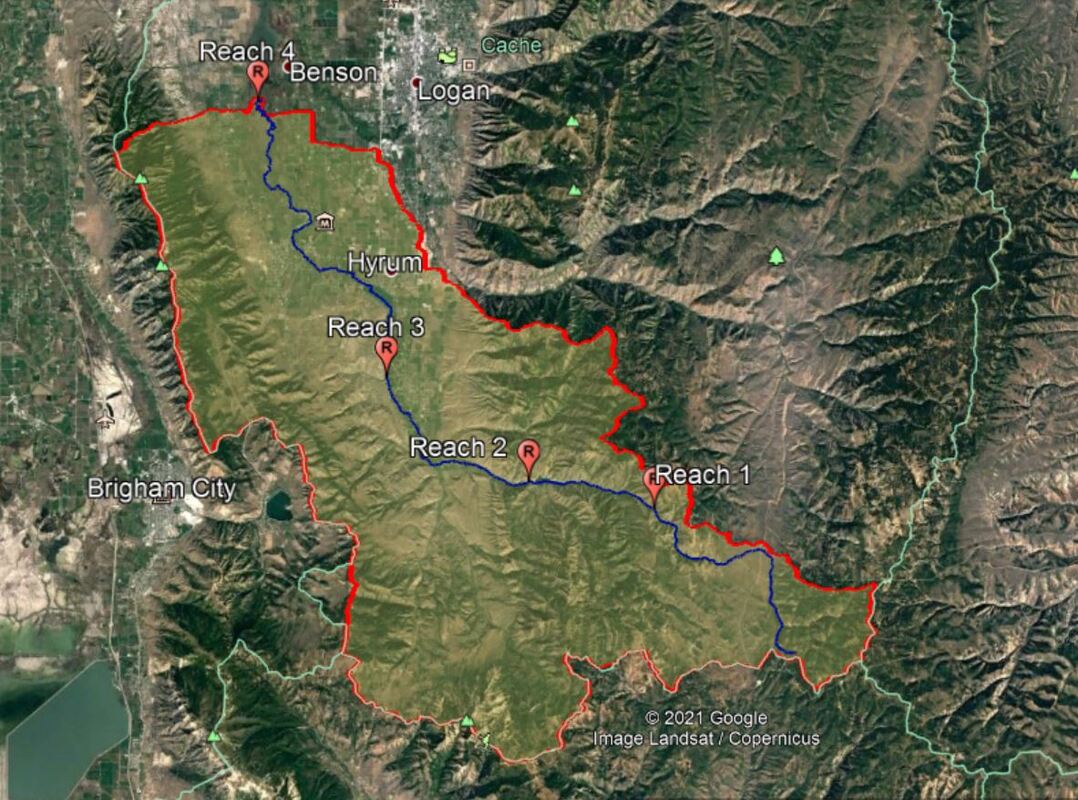
Figure 11: Location of the reach in catchment context
|
|
The catchment area upstream of the Reach 2 is approximately 178.76 square kilometers which significantly governs the discharge in the river at that reach in normal situation. However, the construction of dam completely alters the expected flow regime which will be discussed later. The elevation at the upstream and downstream point of reach 2 are 1595 masl and 1572 masl respectively. This means in a span of 1.0 km the elevation of the river drops by 23 meters (2.3% slope). This reach is 2 times milder than the reach 1.

Figure 13: Reach 2 planform with valley bottom margins and confining stretches
The reach is contained in the valley between the hills on both sides. However the valley is broad enough for the river to adjust laterally. There are some stretches along the reach where the river kisses the valley bottom margin (Figure 13). Towards the end of the reach a fan comes from the right and pushes the river towards the left valley bottom. The river reach is confined by 32% and hence it is a partially confined reach classified as a planform controlled river style. The planform appears to be a low sinuosity meandering river reach with a sinuosity of 1.2 only.
Considerable amount of floodplain is present in this river reach. However, the floodplain doesn't seem to be continuously flooded anymore which can be inferred from the thick vegetation in the floodplain. This is largely due to the presence of the Porcupine reservoir just upstream of the reach which attenuates the peak discharge. This restricts the natural tendency of the river to adjust to some different planform. In fact reach 2 only gets a controlled flow from the reservoir and sediment supply from upstream is also restricted.
This reach has coarse bed materials which can be realised in the pictures below. Due to the presence of dam, the sediments coming to the river from the hill slopes on the sides contribute the sediment distribution. Thats why the sediments are elongated and have rough surface as they get to travel a short distance (they are less rounded). Similarly, the river has milder slope and formation of bars can also be seen. A few bends possess point bars and bank attached bars can also be found. Structural forcing by woody debris is also prominient in this reach whic can be seen in the pictures below. In a few places there are large boulders too.
The evolution of this reach in the near future largely depends on the regulation of the dam. This reach mostly gets a controlled by from the dam. It might take a lot of time for this reach to go through some significant changes. There is very less possibility of the geomorphic units to be reworked.
A concise summary table for this reach is given in the synthesis.
